


Greenhouse Gas Mapping
Background
Greenhouse gases strongly absorb electromagnetic radiation in many parts of the infrared spectrum. Methane (CH4) and carbon dioxide (CO2) have distinct absorption features in in the shortwave infrared (1400-2500nm). Reflected solar radiance measured by airborne imaging spectrometers AVIRIS-NG and AVIRIS-C can be used to measure increased concentrations of atmospheric methane and carbon dioxide. The plots below (Figure 1, from Thorpe et al. 2017) show the “fingerprints” of methane, carbon dioxide, and water vapor absorption that allows their concentration to be estimated.
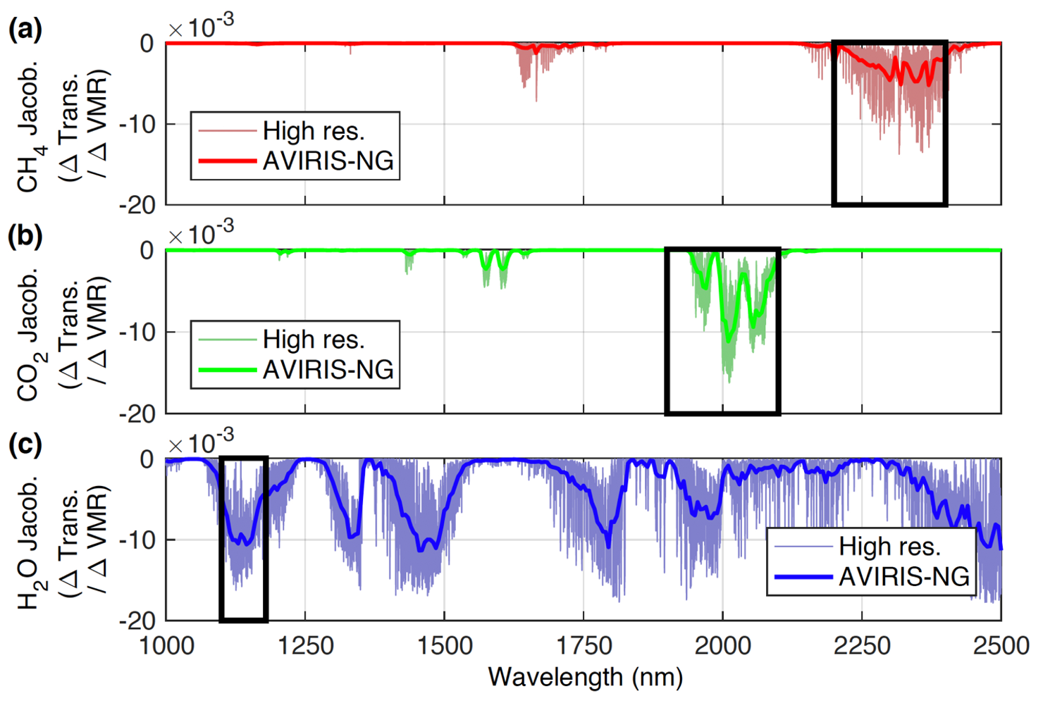
Figure 1. High resolution and AVIRIS-NG absorption spectra for (a) methane (CH4; red), (b) carbon dioxide (CO2; green), and (c) water vapor (H2O; blue). AVIRIS-NG retrieval windows are indicated by the black outlines. See Thorpe et al., 2017 for additional details.
Early work demonstrated detection of methane and carbon dioxide plumes from AVIRIS-C data. Roberts et al. (2010) detected methane plumes from the Coal Oil Point seep field off the coast of California, and Dennison et al. (2013b) detected carbon dioxide plumes from multiple fossil fuel power plants. Subsequent research has developed algorithms that retrieve the enhancement of methane and carbon dioxide concentration above background from AVIRIS-NG data (Thorpe et al., 2014, 2017; Thompson et al., 2015; Cusworth et al., 2019; Foote et al., 2020), which allows for estimates of emissions rates (Frankenberg et al., 2016; Duren et al., 2019). The figures below demonstrate retrieval of enhancements from AVIRIS-NG radiance data for a natural gas processing plant (Figure 2) and a coal power plant (Figure 3).
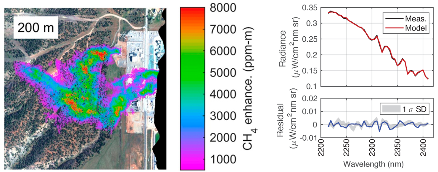
Figure 2. Methane plumes for a natural gas processing plant and an example of retrieval fit between AVIRIS-NG measured radiance (Meas.) and modeled radiance.
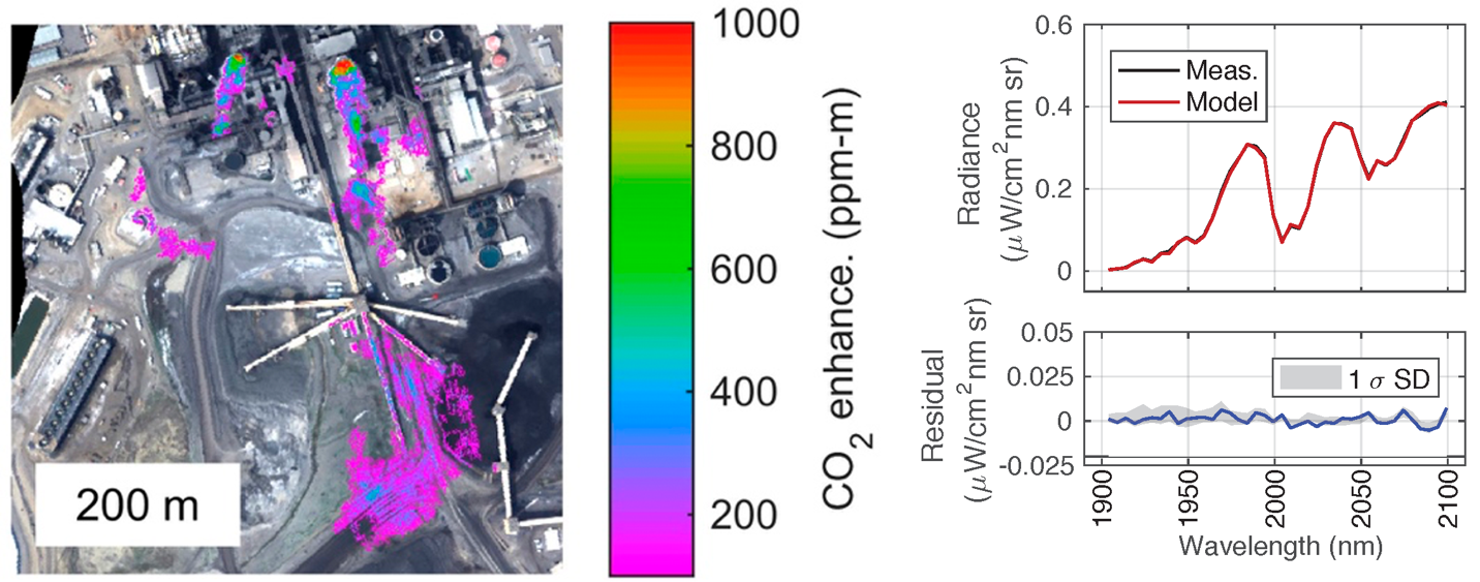
Figure 3. Carbon dioxide plumes from a coal-fired power plant and an example of retrieval fit between AVIRIS-NG measured radiance (Meas.) and modeled radiance.
Since 2015, a number of AVIRIS-NG campaigns for characterizing point source methane emissions have been completed in Colorado, New Mexico, California, Alaska, Canada, and Texas (Table 1). The Four Corners Methane Campaign characterized over 250 individual methane plumes associated with coal bed methane extraction, with the top 10% of emitters responsible for half of the total observed point source contribution (Frankenberg et al., 2015). The California Methane Survey (Duren et al., 2019) identified and quantified point source emissions from over 550 energy, waste management, and agriculture sources. Estimated emissions from methane point sources in California are estimated at 0.618 TgCH4 yr-1 (95% confidence 0.523-0.725), which is equivalent to 34-46% of 2016 California methane inventory. Landfills were responsible for 41% of the observed methane point-source emissions in California, followed by dairies (26%) and the oil and gas sector (26%).
Methane data from the California Methane Survey is available on the ORNL DAAC and through the Methane Source Finder web portal. Additional studies have explored the underground gas storage (Thorpe et al., 2020) and waste management (Cusworth et al., 2020a) sectors, improved retrieval algorithms (Foote et al., 2020), improved methods for estimating emission rates (Jongaramrungruang et al., 2020), and multi-tiered observing systems (Cusworth et al., 2020b).
With summer flights starting in 2017, the Arctic Boreal Vulnerability Experiment (ABoVE) has identified methane hotspots for 0.2% of the surveyed area that follow a two‐component power law as a function of distance from standing water (Elder et al., 2020). Methane hotspots decreased sharply over the first 40 m from standing water, and wide‐ranging methane fluxes at two thermokarst lakes mirror the patterns of remotely sensed hotspots.
These airborne campaigns have resulted in emission mitigation (Duren et al., 2019, Thorpe et al., 2020, Cusworth et al., 2020b) and facilitated studies to better understand the methane sensitivities of future orbital imaging spectrometers like EMIT (Ayasse et al. 2019), EnMAP, and other instruments (Cusworth et al., 2019). A full list of publications is provided below.
Table 1: Recent AVIRIS-NG methane campaigns
| AVIRIS-NG Methane Campaign | Focus Region | Objective | Dates |
|---|---|---|---|
| Four Corners Methane Campaign | Colorado, New Mexico | Identify and quantify methane point source emissions from energy sector | 4/19/15-4/23/15 |
| California Methane Survey | California | Identify and quantify methane point source emissions from energy, waste management, and agriculture sectors | 9/16-11/16, 8/17-11/17, 9/18-10/18 |
| Arctic Boreal Vulnerability Experiment (ABoVE) | Alaska, Canada | Characterize arctic methane hotspot patterns associated with proximity to standing water | 6/17-8/17, 7/18-8/18, 7/19-8/19 |
| Texas Methane eXperiment (TexMeX) | Texas | Quantify energy sector emissions from Permian Basin | 9/19-10/19 |
While carbon dioxide emissions have not been the focus of AVIRIS-NG campaigns to date, many power plants have been overflown as part of campaigns in the US and India. Recent work has demonstrated retrieval of carbon dioxide emissions from power plants (Cusworth et al., in review).
Benchmark Greenhouse Gas Datasets
The following benchmark datasets are intended as a useful tool for algorithm development and testing of greenhouse gas retrieval methods for imaging spectrometers.
- 2017 Benchmark Methane Data - This dataset contains a single AVIRIS-NG scene from the Four Corners campaign with distinct methane plumes.
- 2020 Benchmark Dataset for Methane and Carbon Dioxide Plumes - This dataset contains ten AVIRIS-NG scenes from a variety of campaigns. The scenes include methane plumes from oil and natural gas infrastructure, landfills, wastewater treatment, mining, and agricultural emissions. The scenes also include carbon dioxide plumes from four power plants.
Publications
2020:
- Cusworth, D.H., Duren, R.M., Thorpe, A.K., Tseng, E., Thompson, D.R., Guha, A., Newman, S., Foster, K., Miller, C.E. (2020a). Using remote sensing to detect, validate, and quantify methane emissions from California solid waste operations. Environmental Research Letters.
- Cusworth, D.H., Duren, R.M., Yadav, V., Thorpe, A.K., Verhulst, K., Sander, S., Hopkins, F., Rafiq, T. and Miller, C.E., 2020b. Synthesis of Methane Observations Across Scales: Strategies for Deploying a Multitiered Observing Network. Geophysical Research Letters, 47(7), p.e2020GL087869.
- Elder, C.D., Thompson, D.R., Thorpe, A.K., Hanke, P., Walter Anthony, K.M. and Miller, C.E., 2020. Airborne Mapping Reveals Emergent Power Law of Arctic Methane Emissions. Geophysical Research Letters, 47(3), p.e2019GL085707.
- Foote, M.D., Dennison, P.E., Thorpe, A.K., Thompson, D.R., Jongaramrungruang, S., Frankenberg, C., Joshi, S.C. (2020). Fast and accurate retrieval of point-source methane emissions from imaging spectrometer data using sparsity prior. IEEE Transactions on Geoscience and Remote Sensing.
- Guha, A., Newman, S., Fairley, D., Dinh, T.M., Duca, L., Conley, S., Smith, M.L., Thorpe, A., Duren, R.M., Cusworth, D. and Foster, K., 2020. Assessment of Regional Methane Emissions Inventories through Airborne Quantification in the San Francisco Bay Area. Environmental Science & Technology.
- Rafiq, T., Duren, R.M., Thorpe, A.K., Foster, K, Patarsuk, R., Mille, C.E., Hopkins, F.M. (2020). Attribution of Methane Point Source Emissions using Airborne Imaging Spectroscopy and the Vista-California Methane Infrastructure Dataset. Environmental Research Letters.
- Thorpe, A.K., Duren, R., Conley, S., Prasad, K., Bue, B., Yadav, V., Foster, K., Rafiq, T., Hopkins, F., Smith, M. and Fischer, M.L., 2020. Methane emissions from underground gas storage in California. Environmental Research Letters.
2019:
- Ayasse, A.K., Dennison, P.E., Foote, M., Thorpe, A.K., Joshi, S., Green, R.O., Duren, R.M., Thompson, D.R. and Roberts, D.A., 2019. Methane Mapping with Future Satellite Imaging Spectrometers. Remote Sensing, 11(24), p.3054.
- Cusworth, D.H., Jacob, D.J., Varon, D.J., Miller, C.C., Lu, X., Chance, K., Thorpe, A.K., Duren, R.M., Miller, C.E., Frankenberg, C., Randles, C.A. (2019). Potential of next-generation imaging spectrometers to detect and quantify methane point sources from space. Atmospheric Measurement Techniques.
- Duren, R.M., Thorpe, A.K., Foster, K., Rafiq, T., Hopkins, F.M., Yadav, V., Bue, B.D., Conley, S., Colombi, N., McCubbin, I., Frankenberg, C., Thompson, D.R., Falk, M., Herner, J., Croes, B., Green, R.O., Miller, C.E. (2019). California’s methane super-emitters. Nature.
- Jongaramrungruang, S., Frankenberg, C., Matheou, G., Thorpe, A.K., Kuai, L., Thompson, D.R., Duren, R. M. (2019). Towards accurate methane point-source quantification using high spatial resolution spatial methane mapping. Atmospheric Measurement Techniques.
- Thompson, D.R., Guanter, L., Berk, A. et al. Retrieval of Atmospheric Parameters and Surface Reflectance from Visible and Shortwave Infrared Imaging Spectroscopy Data. Surv Geophys 40, 333–360 (2019). https://doi.org/10.1007/s10712-018-9488-9.
2018:
- Ayasse, A.K., Thorpe, A.K., Roberts, D.A., Funk, C.C., Dennison, P.E., Frankenberg, C., Steffke, A., Aubrey, A.D. (2018). Evaluating the effects of surface properties on methane retrievals using a synthetic Airborne Visible/Infrared Imaging Spectrometer Next Generation (AVIRIS-NG) image. Remote Sensing of Environment, 215, 386-397.
2017:
- Krautwurst, S., Gerilowski, K., Jonsson, H.H., Thompson, D.R., Kolyer, R.W., Iraci, L.T., Thorpe, A.K., Horstjann, M., Eastwood, M., Leifer, I., Vigil, S.A. (2017). Methane emissions from a Californian landfill, determined from airborne remote sensing and in situ measurements. Atmospheric Measurement Techniques, 10(9), 3429.
- Thorpe, A.K., Frankenberg, C., Thompson, D.R., Duren, R.M., Aubrey, A.D., Bue, B.D., Green, R.O., Gerilowski, K., Krings, T., Borchardt, J., Kort, E.A. (2017). Airborne DOAS retrievals of methane, carbon dioxide, and water vapor concentrations at high spatial resolution: Application to AVIRIS-NG. Atmospheric Measurement Techniques, 10(10), 3833.
2016:
- Frankenberg, C., Thorpe, A.K., Thompson, D.R., Hulley, G., Kort, E.A., Vance, N., Borchardt, J., Krings, T., Gerilowski, K., Sweeney, C., Conley, S. (2016). Airborne methane remote measurements reveal heavy-tail flux distribution in Four Corners region. Proceedings of the National Academy of Sciences, 201605617.
- Thompson, D.R., Thorpe, A.K., Frankenberg, C., Green, R.O., Duren, R., Guanter, L., Hollstein, A., Middleton, E., Ong, L., Ungar, S. (2016). Space‐based remote imaging spectroscopy of the Aliso Canyon CH4 superemitter. Geophysical Research Letters, 43(12), 6571-6578.
- Thorpe, A.K., Frankenberg, C., Roberts, et al. (2016a). Mapping methane concentrations from a controlled release experiment using the next generation Airborne Visible/Infrared Imaging Spectrometer (AVIRIS-NG). Remote Sensing of Environment, 179, 104-115.
- Thorpe, A. K., Frankenberg, C., Green, R. O., Thompson, D. R., Mouroulis, P., Eastwood, M.L., Matheou, G. (2016b). The Airborne Methane Plume Spectrometer (AMPS): Quantitative imaging of methane plumes in real time, paper presented at Aerospace Conference, 2016 IEEE.
2015:
- Aubrey, A.D., Frankenberg, C., Green, R.O., Eastwood, M.L., Thompson, D.R., Thorpe, A.K. (2015). Crosscutting airborne remote sensing technologies for oil and gas and earth science applications, paper presented at Offshore Technology Conference, Houston, Texas.
- Thompson, D.R., Leifer, I., Bovensmann, H., Eastwood, M.L., Green, R.O., Eastwood, M.L., Fladeland, M., Frankenberg, C., Gerilowski, K., Green, R.O., Kratwurst, S., Krings, T., Luna, B., Thorpe, A.K. (2015). Real time remote detection and measurement for airborne imaging spectroscopy: A case study with methane. Atmospheric Measurement Techniques, 8, 4383-4397.
2014:
- Thorpe, A.K., Frankenberg, C., Roberts, D.A. (2014). Retrieval techniques for airborne imaging of methane concentrations using high spatial and moderate spectral resolution: Application to AVIRIS. Atmospheric Measurement Techniques, 7, 491-506.
2013:
- Dennison, P.E., Thorpe, A.K., Qi, Y., Roberts, D.A., Green, R.O. (2013a). Modeling sensitivity of imaging spectrometer data to carbon dioxide and methane plumes. Proc. Workshop on Hyperspectral Image and Signal Processing: Evolution in Remote Sensing (WHISPERS).
- Dennison, P.E., Thorpe, A.K., Qi, Y., Roberts, D.A., Green, R.O., Bradley, E.S., Funk, C.C. (2013b). High spatial resolution mapping of elevated atmospheric carbon dioxide using airborne imaging spectroscopy: Radiative transfer modeling and power plant plume detection. Remote Sensing of Environment, 139, 116–129.
- Thorpe, A.K., Roberts, D.A., Bradley, E.S., Funk, C.C., Dennison, P.E., Leifer I. (2013). High resolution mapping of methane emissions from marine and terrestrial sources using a Cluster-Tuned Matched Filter technique and imaging spectrometry. Remote Sensing of Environment, 134, 305–318.
2012:
- Thorpe, A.K., Roberts, D.A., Dennison, P.E., Bradley, E.S., Funk, C.C. (2012). Point source emissions mapping using the Airborne Visible/Infrared Imaging Spectrometer (AVIRIS). Proc. SPIE, 8390, 839013.
2011:
- Bradley, E.S., Leifer, I., Roberts, D.A., Dennison, P.E. and Washburn, L., 2011. Detection of marine methane emissions with AVIRIS band ratios. Geophysical Research Letters, 38(10).
2010:
- Roberts, D.A., Bradley, E.S., Cheung, R., Leifer, I., Dennison, P.E. and Margolis, J.S., 2010. Mapping methane emissions from a marine geological seep source using imaging spectrometry. Remote Sensing of Environment, 114(3), pp.592-606.