


Benchmark Dataset for Methane and Carbon Dioxide Plumes
Multiple studies have demonstrated successful retrieval of methane (CH4) and carbon dioxide (CO2) plumes from airborne imaging spectrometer data, but comparison of retrieval algorithms and concentration enhancement results has been made more difficult by the lack of common benchmark data. Ten AVIRIS-NG scenes capturing a variety of methane and carbon dioxide point source emissions in the United States and India have been curated into a benchmark dataset. Images were selected to span a wide range of sources, enhancements, geometries, and atmospheric conditions. Methane point sources captured in the dataset include landfills, oil and natural gas infrastructure, wastewater treatment, a dairy facility, and a mine. Four fossil fuel power plants comprise the carbon dioxide point sources in the dataset.
Methane and carbon dioxide retrievals were run using the mag1c L1 sparse, albedo corrected matched filter (Foote et al., 2020). Examples of methane and carbon dioxide enhancements from each scene are shown below.
Benchmark Dataset Metadata >> Benchmark Dataset Documentation >>ang20150420t181345
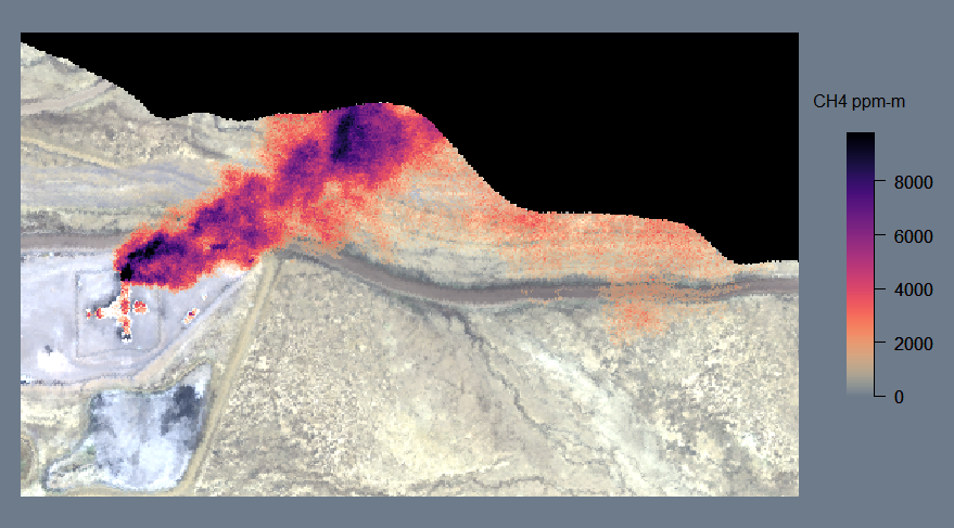
Figure 1. A methane plume emitted by a coal mine vent in scene ang20150420t181345. Methane concentration-path length enhancement (in ppm-m) is shown in the scale at right.
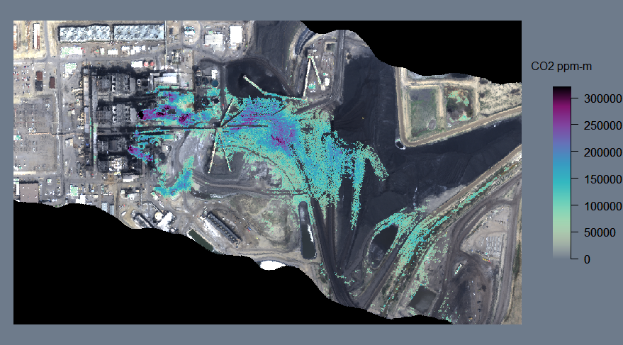
Figure 2. Carbon dioxide plumes emitted from a coal power plant in scene ang20150420t181345. Carbon dioxide concentration-path length enhancement (in ppm-m) is shown in the scale at right.
This scene was acquired west of Farmington, New Mexico, USA and contains both a methane plume from a coal mine vent (Figure 1) and carbon dioxide plumes from a coal power plant (Figure 2). This is the highest spatial resolution scene in the dataset, has the lowest column water vapor, and is the only scene containing both methane and carbon dioxide plumes.
Download CH4 and CO2 Retrievals Download Ortho Radiance Download Non-Ortho Radiance Download Reflectanceang20160211t075004
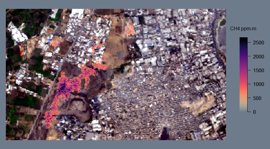
Figure 3. A methane plume emitted by the Pirana landfill in scene ang20160211t075004. Methane concentration-path length enhancement (in ppm-m) is shown in the scale at right.
This scene was acquired during the 2015-2016 NASA-ISRO AVIRIS-NG India Campaign, and contains the widest variety of methane sources in the dataset. The scene captures a large plume emitted by a landfill in Ahmedabad, Gujarat, India (Figure 3). Smaller plumes are associated with wastewater treatment plants and an oil well. This scene has the coarsest spatial resolution of methane scenes within the dataset.
Download CH4 Retrievals Download Ortho Radiance Download Non-Ortho Radiance Download Reflectanceang20170616t212046
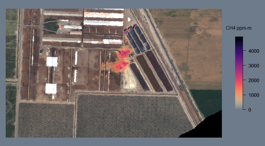
Figure 4. Methane plumes emitted by covered dairy feedlot waste lagoons in scene ang20170616t212046. Methane concentration-path length enhancement (in ppm-m) is shown in the scale at right.
This scene was acquired near Corcoran, California, USA and captures plumes emitted by dairy feedlot waste lagoons. In Figure 4, three plumes combine to one larger plume downwind.
Download CH4 Retrievals Download Ortho Radiance Download Non-Ortho Radiance Download Reflectanceang20170618t193955
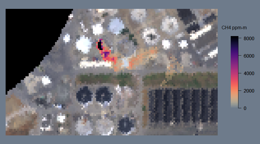
Figure 5. A methane plume emitted from a wastewater treatment plant in scene ang20170618t193955. Methane concentration-path length enhancement (in ppm-m) is shown in the scale at right.
This scene was acquired over San Jose, California, USA, and contains a plume from a wastewater treatment plant (Figure 5) and the downwind portion of a plume from the Newby Island Landfill. This scene complements ang20180927t195028, which includes both the treatment plant and the landfill source. This scene has the smallest solar zenith angle and the highest column water vapor in the dataset.
Download CH4 Retrievals Download Ortho Radiance Download Non-Ortho Radiance Download Reflectanceang20170906t210217
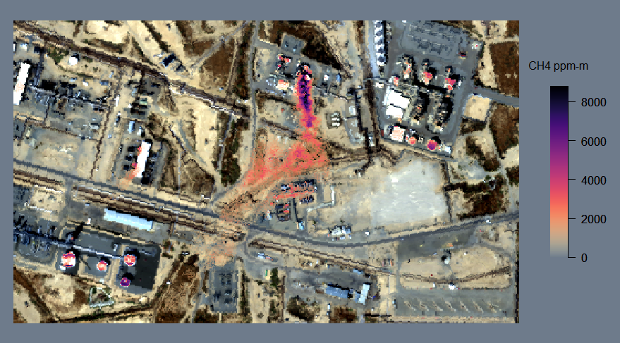
Figure 6. A methane plume emitted from natural gas infrastructure in scene ang20170906t210217. Methane concentration-path length enhancement (in ppm-m) is shown in the scale at right.
This scene was acquired over the Elk Hills oil and natural gas field in the San Joaquin Valley, California, USA. It contains methane plumes from natural gas infrastructure (Figure 6).
Download CH4 Retrievals Download Ortho Radiance Download Non-Ortho Radiance Download Reflectanceang20180415t045439
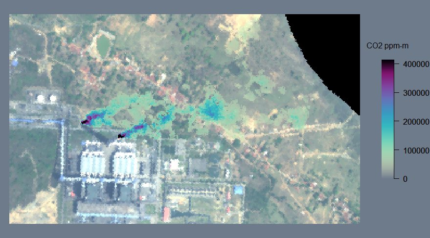
Figure 7. Power plant carbon dioxide plumes in scene ang20180415t045439. Carbon dioxide concentration-path length enhancement (in ppm-m) is shown in the scale at right.
This scene was acquired over Maithon, Jharkhand, India during the NASA-ISRO 2018 AVIRIS-NG Indian Campaign. The scene contains two carbon dioxide plumes emitted from coal power plant smokestacks (Figure 7).
Download CO2 Retrievals Download Ortho Radiance Download Non-Ortho Radiance Download Reflectanceang20180927t195028
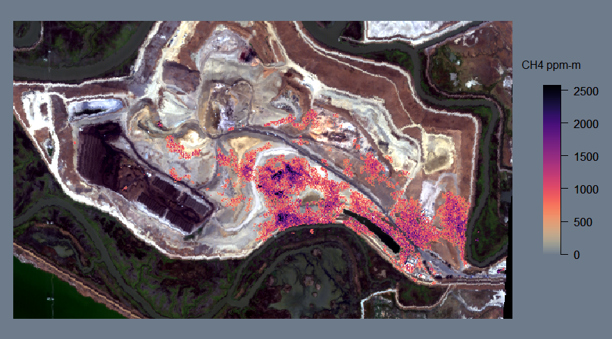
Figure 8. Methane enhancements over the Newby Island Landfill in scene ang20180927t195028. Methane concentration-path length enhancement (in ppm-m) is shown in the scale at right.
This scene was acquired over San Jose, California, USA. It includes methane emissions from the Newby Island Landfill (Figure 8) as well as a plume from a wastewater treatment plant. The scene complements scene ang20170618t193955, which includes plumes from the same two sources.
Download CH4 Retrievals Download Ortho Radiance Download Non-Ortho Radiance Download Reflectanceang20190621t200919
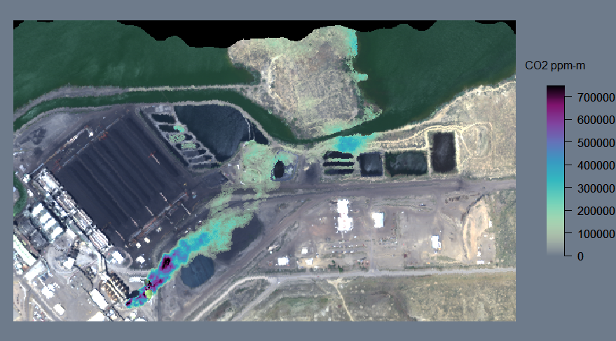
Figure 9. A carbon dioxide plume from a coal power plant in scene ang20190621t200919. Carbon dioxide concentration-path length enhancement (in ppm-m) is shown in the scale at right.
This scene was acquired west of Farmington, New Mexico, USA. It contains a carbon dioxide plume from the Four Corners coal power plant (Figure 9). This scene has the smallest solar zenith angle for carbon dioxide scenes within the dataset.
Download CO2 Retrievals Download Ortho Radiance Download Non-Ortho Radiance Download Reflectanceang20191004t221515
Figure 10. Carbon dioxide enhancements associated with coal and natural gas power plants in scene ang20191004t221515. Carbon dioxide concentration-path length enhancement (in ppm-m) is shown in the scale at right.
This scene was acquired over the W.A. Parish coal and natural gas power plants southwest of Houston, Texas, USA. Carbon dioxide enhancements are visible adjacent to smokestacks for the coal power plant (Figure 10, center) and over the natural gas plant (Figure 10, top center); however, there are no definitive, large, plume-like features in this scene when processed using the L1-sparse albedo-corrected matched filter described in Foote et al. (2020). This scene has the largest solar zenith angle within the dataset, and the coarsest spatial resolution.
Download CO2 Retrievals Download Ortho Radiance Download Non-Ortho Radiance Download Reflectanceang20191023t151141
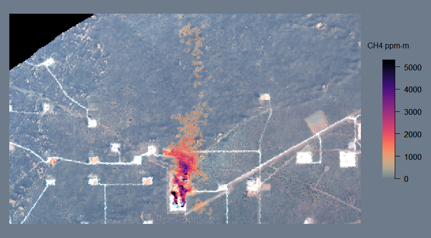
Figure 11. Methane plumes from natural gas infrastructure in scene ang20191023t151141. Methane concentration-path length enhancement (in ppm-m) is shown in the scale at right.
This scene was acquired over an oil and natural gas field near Carlsbad, New Mexico, USA, within the Permian Basin. Several methane plumes can be found within the scene. This scene has the largest solar zenith angle of methane scenes within the dataset.
Download CH4 Retrievals Download Ortho Radiance Download Non-Ortho Radiance Download Reflectance