Benchmark Methane Data
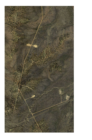
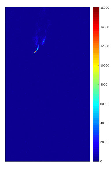
Methane (CH4) is a powerful greenhouse gas. CH4 enters the atmosphere from various sources: naturally, from phenomena like geologic seeps; and artificially, through a range of processes like animal husbandry, decomposition in landfills, and oil and gas extraction and production. Institutions like the Jet Propulsion Laboratory are developing automated methods for the reliable detection, and potentially classification, of CH4 sources from imaging spectrometer data. The key challenge is to distinguish CH4 sources from background noise. Domain experts currently perform this task manually by visual inspection of the imaging spectrometer data. In consort with the NSF-sponsored Research Coordination Network on Intelligent Systems Research to Support Geosciences (IS-GEO, https://is-geo.org/), we have prepared a benchmark dataset to promote future research on automated detection. The dataset, designated JPL-CH4-detection- 2017-V1.0, contains sample imaging spectrometer data acquired in the "Four Corners" area - a hotspot of CH4. This document describes the dataset to researchers developing and testing algorithms for CH4 detection from imaging spectrometer data. The benchmark includes, (1) this description and (2) the dataset. The data was provided by the Jet Propulsion Laboratory using the Next Generation Airborne Visible Infrared Imaging Spectrometer (AVIRIS-NG, https://avirisng.jpl.nasa.gov/).