


Platform
Currently AVIRIS-NG flies on a King Air B200 operated by Dynamic Aviation Group Inc from Bridgewater, Virginia. The Kind Air B200 flies at a maximum altitude of 35 kft (10.6 km).
NASA’s high altitude sensor platform, the ER-2 operated by NASA's Armstrong Flight Research Center, and another mid altitude aircraft, the DHC-6 operated by Twin Otter International Ltd (TOIL), are also available platforms.
AVIRIS-NG Peformance and Flight Parameters are listed below:
The critical aircraft performance requirement is for a capability of acquiring low altitude, high resolution imaging spectrometer data with NASA hyperspectral scanner.
- Altitude regimes: 6,000 ft AGL to 20,000 ft Above Ground Level (AGL)
- Minimum ground speed: 70 kts @ 6,500 ft AGL for 2 meter pixel resolution
- Average ground speed: 100 kts @ 13,000 ft AGL for 4 meter pixel resolution
- Maximum ground speed: 128 kts @ 20,000 ft AGL for 6 meter pixel resolution
- Range: 700 nautical miles (5 hours)

The AVIRIS-NG instrument accommodation in the DHC-6 aircraft.
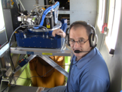
AVIRIS-NG installed over the standard camera port of the DHC-6 .