Skip to Navigation | Skip to Content

NASA Jet Propulsion Laboratory California Institute of Technology

Airborne Visible / Infrared Imaging Spectrometer, Next Generation Logo

AVIRIS Next Generation

Welcome

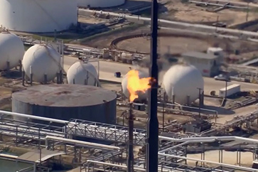
  • NASA scientists track climate-changing methane leaks from the air

    NASA engineers leverage state-of-the-art technology to measure methane. Released through oil and gas production, livestock emissions, and organic waste, methane is about 85 times more potent at trapping heat than carbon dioxide.

    More »
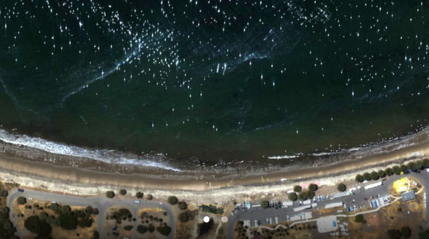
  • NASA/JPL’s AVIRIS-NG Maps Beach Tar from California Oil Pipeline Spill

    In support of the response to the Refugio Incident, NASA/JPL deployed a Twin Otter aircraft carrying a unique airborne instrument to study the spill and test the ability of imaging spectroscopy to map tar on area beaches. The work is advancing our nation's ability to respond to future oil spills.

    More »
  • NASA/JPL’s AVIRIS-NG Studies Louisana’s Changing Wetlands

    NASA recently completed an intensive study of Louisiana Gulf Coast levees and wetlands, making measurements with three advanced imaging instruments (UAVSAR, AirSWOT, and AVIRIS-NG) on two research aircraft.

    More »
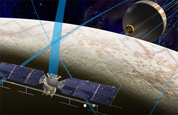
  • NASA Selects JPL Imaging Spectrometer for Europa Mission

    NASA has selected nine science instruments for a mission to Jupiter's moon Europa, to investigate whether the mysterious icy moon could harbor conditions suitable for life. JPL’s Mapping Imaging Spectrometer for Europa (MISE) whose principal investigator is Dr. Diana Blaney of JPL, will probe the composition of Europa, identifying and mapping the distributions of organics, salts, acid hydrates, water ice phases, and other materials to determine the habitability of Europa's ocean.

    More »
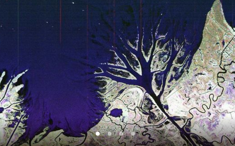
  • NASA/JPL's AVIRIS-NG joins investigation into mysterious methane hot spot

    NASA researchers have joined scientists from a variety of other institutions to try to solve the mystery of the four-corners (the intersection of Utah, Colorado, Arizona and New Mexico) methane hot-spot. Researchers from JPL will use two Twin Otter research aircraft to fly two remote sensing instruments over the area, AVIRIS-NG and the Hyperspectral Thermal Emission Spectrometer (HyTES). AVIRIS-NG will be used to map methane at fine resolution over the entire region.

    More »


The Airborne Visible-Infrared Imaging Spectrometer - Next Generation (AVIRIS-NG) has been developed to provide continued access to high signal-to-noise ratio imaging spectroscopy measurements in the solar reflected spectral range. AVIRIS-NG is expected to replace the AVIRIS-Classic instrument that has been flying since 1986.

AVIRIS-NG measures the wavelength range from 380 nm to 2510 nm with 5 nm sampling. Spectra are measured as images with 600 cross-track elements and spatial sampling from 0.3 m to 4.0 m from a Twin Otter platform. In the near future, a high altitude platform (NASA's ER-2) will be available. AVIRIS-NG has better than 95% cross-track spectral uniformity and >= 95% spectral IFOV uniformity.

AVIRIS-NG has been calibrated and deployed with a new high-rate data-capture system and a new real-time cloud-screening algorithm to support a methane-release experiment at the Department of Energy’s Rocky Mountain Oil Field Test Center. This instrument’s capability to detect and measure methane point sources is of interest for both greenhouse gas research and natural resource exploration, and the onboard cloud-screening algorithm is applicable for space imaging spectrometer missions.

We use the terms "imaging spectroscopy" and "imaging spectrometer data" to communicate most clearly with our astronomy, physics, chemistry, and biology science colleagues who are already familiar with spectroscopic measurements.